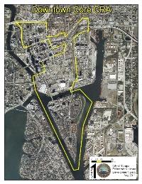
That tract of land lying in Sections 13 and 24 of Township 29 South, Range IB East, AND in Section 19 Township 29 South, Rangu 19 East as located in Hillsborough County, Florida, more particularly described as follows to wit: Begin at the intersection of the Southwesterly projection of the Centerline of Whiting Street as shown on TAMPA, a subdivision of record in Plat Book 1, Page 7 of the Public Records of Hillsborough County, Florida, with a Centerline in the Hillsborough River, said Centerline being that between the Easterly and Westerly combined Pierhead and Bulkhead Lines of said River as determined by the Jacksonville District, Corps of Engineers of the Department of the Army and shown on their drawing of the U.S. Harbor Lines, Tampa Harbor, Florida, Hillsboro River and Hillsboro Bay, Sheet No. 3, File 454-20,641; run thence Northeasterly along said projection and Centerline of Whiting Street to the Centerline of Monroe Street (Florida Avenue) in said Subdivision; run thence Northwesterly along said Centerline to the Centerline of Lafayette Street (John F. Kennedy Boulevard) in said Subdivision; run thence Northeasterly along said Centerline and its Easterly projection to the Centerline of the Eastbound Lane of the Eastern extension to I-75 of the Tampa South Crosstown Expressway Project (State Road 618); run thence Northeasterly along said Centerline to the Centerline of Drew Avenue (as shown on DREW'S ADDITION TO TOWN OF TAMPA, a subdivision of record in Deed Book "K", Page 534); run thence Northwesterly along said Centerline to the Easterly projection of the Centerline o-f Twiggs Street as shown on said TAMPA Subdivision; run thence Southwesterly along said projection and Centerline to the Centerline of Jefferson Street as shown on said TAMPA subdivision; run thence Northwesterly along said Centerline to the Centerline of Cass Street as shown on said TAMPA Subdivision; run thence Southwesterly along said projection and Centerline to the Centerline of the Southbound Lane of Ashley Drive Interstate Expressway Connector, as shown on RIVERFRONT SUBDIVISION EAST, of record in Plat Book 42, Page 56 of the Public Records of Hillsborough County, Florida; run thence Northerly and Northwesterly along said Centerline to the Centerline of the Scott Street exit ramp of the State of Florida-State Road Department Interstate Expressway No. 4, as shown on said RIVERFRONT SUBDIVISION EAST; run thence Southwesterly along said Centerline to its intersection with a Centerline in the Hillsborough River, said Centerline being that between the Easterly and Westerly combined Pierhead and Bulkhead lines of said River as determined by the Jacksonville District, Corps of Engineers of the Department of the Army, and shown on their drawing of the U.S. Harbor Lines,Tampa Harbor, Florida, Hillsboro River and Hillsboro Bay, Sheet No. 3, File 454-20,641; run thence Southwesterly and Southeasterly along said Centerline to the Point of Beginning of the tract herein described.
Downtown Non Core CRA Legal Description
Was this page helpful? or
Thanks for letting us know!
Help us improve by leaving a quick comment
- Tell us what was confusing, missing or inaccurate about this page.
- We will not reply to comments, use the Page Enhancement Request below if you want a formal reply.
- Do not submit any personal or sensitive information such as account numbers or names.
- OR-
For a formal response complete the Page Enhancement Request form.